

1. Introduction
Sustainable integrated districts are planned to improve the quality of life in high-density cities. They achieve the goal through a ‘socio-spatial integration design’ strategy. As part of the strategy, different land-uses and activities are incorporated into well-connected districts to boost their vibrancy and liveliness. The pedestrian systems in sustainable integrated districts want to provide attractive and accessible circulation. By improving access to services and amenities, the increased connectivity is meant to support a range of activities. People living or working in sustainable integrated districts are provided with more opportunities to interact spontaneously. In addition, well-designed and connected communal green spaces encourage a sense of belonging among diverse populations, thereby promoting overall social integration and inclusion in these districts.
The Social Performance study ventures into the social dimensions of sustainable integrated districts, seeking to understand the interplay between integrative design strategies, such as mixed-use developments, and the tangible outcomes in terms of social performance. The work package asks the research question:
Does, and to what extent, the strategy of spatial integration translate into social integration in sustainable integrated districts? This means facilitating the integration of various communities within a sustainable integrated district.
2. Methodology
Methodologically, the relative success of sustainable integrated districts, in terms of social integration, was addressed through case studies. These include one-north and its corresponding control case Kent Ridge. Raw GPS data served as the main source to assess social performance. The GPS data provided geo-proxies that were used for community identification at the scale of individuals by analysing anonymous users’ travel patterns over time allowed for the grouping of users by mobility similarities, the inferencing of a range of social attributes (Figure 1). This research primarily focussed on two types of social attributes – socio-economic groups (income level) and activity groups – which served as aspects of social integrations.

Figure 1. GPS users’ travel pattern
Not all types of interactions are beneficial in terms of achieving higher levels of social integration. A heterophilous interaction describes an instance where individuals seek to associate with those different from themselves in terms of income levels and activities. It contradicts a homophilous interaction which refers to the tendency for two individuals of the same activity or socio-economic background to bond with each other. In fact, heterophilous interactions might improve social integration in a district, but homophilous interactions might only enhance the sense of a space’s exclusivity and potentially intensify socio-spatial segregation. For this reason, the study differentiated heterophilous and homophilous interactions within the two innovation districts. The indicator for assessing socioeconomic and activity integration is the heterophilous interaction opportunities provided by one-north and Kent Ridge.
3. Main Findings
The study revealed a compelling dynamic: both one-north and Kent Ridge excel in terms of activity-based integration yet lag in achieving socio-economic cohesion. Interestingly, one-north has an edge, providing a larger area (an additional 6 m² per 100 m²) specifically designed to encourage interactions among individuals from diverse income levels when compared to Kent Ridge. This attribute positions one-north as a promising model for mitigating socio-economic segregation in urban districts.
Figure 2 offers a visual representation of the social spaces in both one-north and Kent Ridge, using a colour gradient from blue to red to signify the levels of heterophilous interaction. This plot reveals in both activity-based integration and socio-economic integration metrics, one-north outperforms Kent Ridge, signifying a more integrated and socially cohesive urban environment. Notably, areas around Star-vista and Fusionopolis in one-north have the highest concentration of spaces encouraging heterophilous interactions. Both clusters are characterised by integrated functionalities: Star-vista features a strategically placed shopping mall near a transit station, along with residential buildings that have ground-level commercial spaces, while Fusionopolis is a multidimensional hub combining offices, commerce, and transit facilities. This mixed-use planning in one-north translates into a more fertile ground for heterophilous interactions, suggesting an improved framework for social integration as compared to Kent Ridge.

Figure 2. This plot is presented in two rows to delineate the different aspects of integration. The upper row illustrates the intensity of activity-based integration, while the lower row focuses on the intensity of socio-economic integration. In both metrics, one-north outperforms Kent Ridge, signifying a more integrated and socially cohesive urban environment.
Further analysis narrowed the focus to three smaller sites within one-north or ‘subsites’: Biopolis, Fusionopolis, and Mediapolis. Each serves a unique industry—Biopolis specialises in biomedical research, Mediapolis in digital media, and Fusionopolis in science and engineering. Figure 3 maps the spatial distribution of areas promoting heterophilous interactions within these sub-districts. The findings indicated that Fusionopolis offers the most abundant opportunities for heterophilous interactions among diverse socio-economic and activity groups, denoted by red-colored clusters. Biopolis follows closely, displaying a significant prevalence of semi-heterophilous interactions, as indicated by yellow-colored clusters.
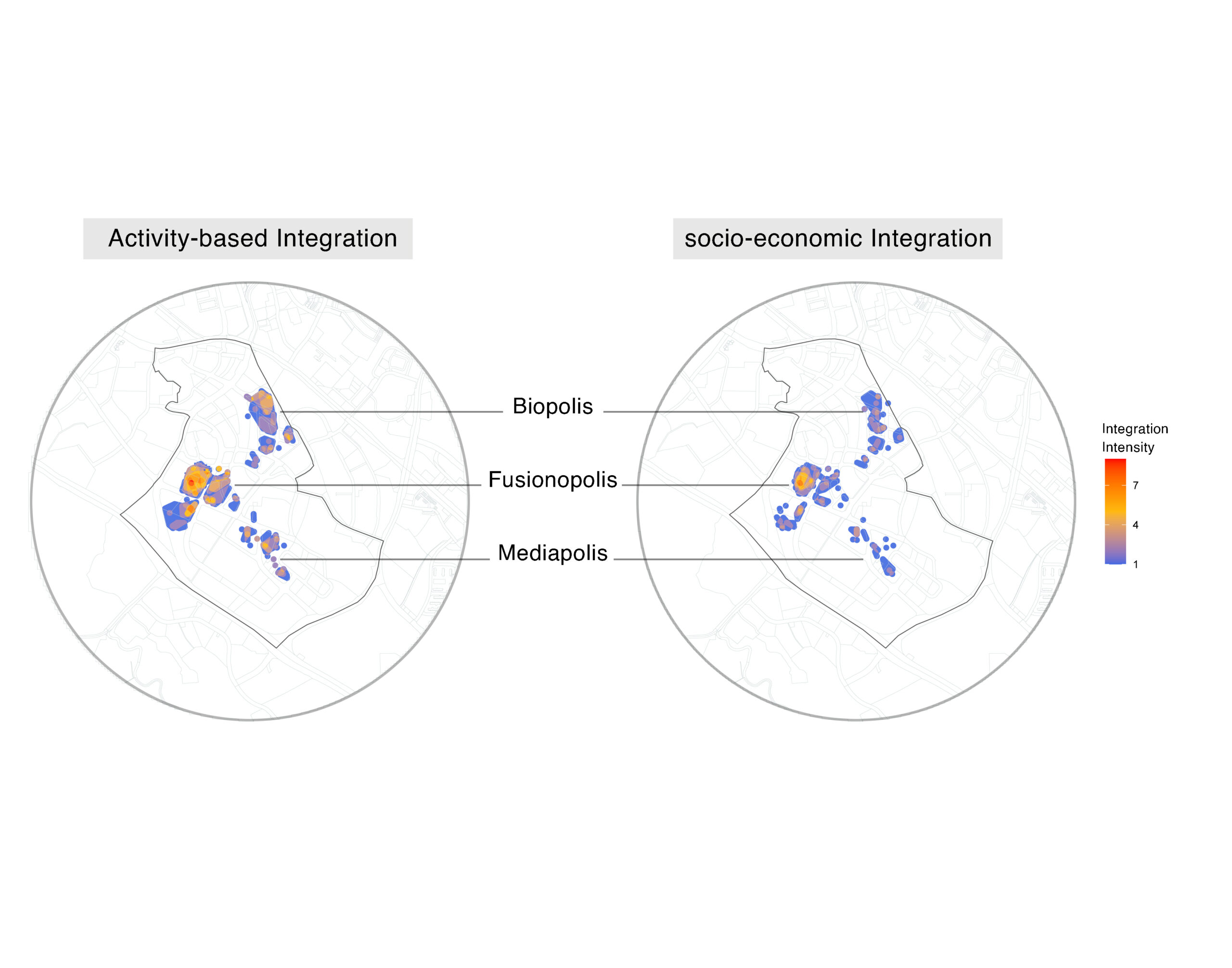
Figure 3. This plot highlights the intensity of activity-based integration (left) and the intensity of socio-economic integration in the three selected subsites.
4. Reference Links
Tongchaoran G., & Samson L. (2023). Socio-spatial integration in innovation districts: Singapore’s mixed-use experiment. Cities. Volume 140, 104405, ISSN 0264-2751. https://doi.org/10.1016/j.cities.2023.104405. https://www.sciencedirect.com/science/article/pii/S0264275123002172
1 Introduction
The Swiss voting population has decided to prioritise inward city development and densification as critical strategies for future growth to tackle the challenge of rapid population increase in urban areas. While densification can lead to benefits such as energy efficiency and reduced greenhouse gas emissions, it also has potential trade-offs. Urban transformation through densification has multifaceted social implications, including fostering social diversity and activity while possibly adversely affecting mental health due to heightened stress levels.
Rather than examining the impact of densification on individuals, research has shifted towards understanding the type of densification that people desire in the urban development process and identifying strategies to mitigate its adverse effects. The social performance work package explores the perceptions of urban development and potential changes in Altstetten and Albisrieden. This involved a qualitative study of community profiles to identify key features and concerns and a quantitative analysis of individual space-use behaviour in four areas. The results showed that green space design is crucial in promoting social integration and cohesion, with the loss of green space being a significant concern for community members.
2 Densification quality for community
2.1 Introduction
Different factors shape the quality of life in a neighbourhood, including demographics, economics, infrastructure, and construction. Comparing different neighbourhoods can help identify opportunities and risks. The study analysing two dense neighbourhoods in Altstetten and Wiedikon aimed to understand people’s perceptions of urban densification and identified vital factors necessary for building a future dense and green neighbourhood, such as affordability, community identity, and displacement. The findings were based on the perspectives of residents, organizations, institutions, and other user groups.
2.2 Methods
To understand the potential for future densification and the types of development that could be implemented, the study first analysed the ratio of residents to jobs in the district. Relevant population data was obtained through open-source information provided by the City of Zurich.
Two case studies, Lindenplatz and Idaplatz, and the surrounding areas within a 500-meter radius were selected for a qualitative study. Guided interviews were conducted with forty passers-by in each case on different days and times to ensure a diverse range of interviewees. The research team also conducted semi-structured interviews with neighbourhood organisations and institutions. Both sets of interviews focused on the current state of the neighbourhoods and potential scenarios for future densification.
The analysis of these interviews served as a guide for visualising potential densification scenarios, which were then discussed with resident groups. Feedback and comments from these discussions were recorded as final suggestions for urban transformation.
2.3 Findings and outcomes
a) Resident-Job position ratio
Altstetten has almost double the population density of Albisrieden, with 80,000 people in 745 hectares compared to over 30,000 people in 460 hectares. Altstetten is a working quarter with a ratio of 0.95 residents to full-time-equivalent job positions, while Albisrieden is a residential quarter with a ratio of 3.21 residents to job positions. In Albisrieden, slightly over a quarter of residents are foreigners, while in Altstetten, over a third of residents are foreigners. Despite significant population growth in both areas, their low density in Zurich suggests they will play essential roles in absorbing future urban population growth.
b) Affordability, green space, and social connection
Affordability, green spaces, and social connection are essential for evaluating densification. High-rise buildings with affordable housing are preferred over luxury skyscrapers due to cost and impact on the ground. People also want more public green spaces and are concerned about increased car traffic from luxury apartments, which could negatively affect social connections in the neighbourhood.
c) Spatial centrality and connectivity
Residents in Lindenplatz and Idaplatz emphasised the importance of spatial centrality and connectivity. Thanks to centralised facilities and well-connected street networks, they appreciate having all their daily necessities within a 10-minute walk. This contributes to their positive attitude towards their neighbourhoods.
d) Local identity and community characteristics
Residents in Altstetten and Idaplatz expressed concerns about local identity and community characteristics during interviews. Altstetten residents appreciate their rural environment and sense of community, while Idaplatz residents were anxious about changes to their lifestyle. Both neighbourhoods agreed to densify, but with community-inclusive and specified urban planning approaches to maintain the different identities of each neighbourhood. The residents stressed the importance of an equitable and inclusive densification process that doesn’t lead to gentrification and displacement of marginalised groups.
Based on the study conducted in the Lindenplatz and Idaplatz neighbourhoods, it was found that the growth in population density due to urban development is acceptable. However, there are essential questions that need to be addressed when it comes to the densification process. These include finding a balance between affordable and commercial housing for people with varying financial situations, providing more facilities and public green spaces for daily use, and preserving each community’s unique identities and characteristics.
3 Space Use
3.1 Introduction
In addition to helping mitigate adverse impacts caused by rapid urban development, urban green spaces, such as parks, gardens, and green walls, promote social well-being and cohesion by encouraging outdoor activities and resident interactions. To optimise their use, factors like proximity, accessibility, size, and engagement must be considered in their design.
The socio-spatial study of public green spaces in Altstetten-Albisrieden examined four clusters to observe space use activities and features in-depth, providing recommendations for future green space design and planning to enhance the quality of living and improve social integration and cohesion in large-scale urban areas. By implementing these recommendations, urban planners can create more effective and efficient public green spaces that enhance urban residents’ quality of life and social well-being.
3.2 Methods
Based on the environmental performance work package, four green space clusters and their 400-metre radius catchments were selected as subsite cases due to their significant positions in the urban fabric and the variation of green space organisation. These four subsite cases are Grünau, Lindenplatz, Bachwiesen and Süsslerenanlage, representing the district’s green space use situation (Figure 1).

Figure 1: Four clusters (subsite cases) in Altstetten and Albisrieden
Onsite non-participant observation was conducted to investigate space use in the four subsite cases. Observed activities were recorded as point features in QGIS with detailed information, such as activity time and types, interactions, and basic descriptions of space users. Photos and videos were used as supplements for data validation.
The observation covered all public, open, and community green spaces in the four cluster cases from 14:00 to 18:30 on two typical weekdays (Tuesday, Wednesday, or Thursday) and Sundays, chosen to ensure similar weather conditions and outdoor temperatures. The observation was conducted in the early summer for two weeks and was repeated for another two weeks in the early autumn of 2022. Information such as language, age, gender, and user types were considered to facilitate the cross-case analysis of how green space attributes influenced the diversity of observed activities.
3.3 Findings and outcomes
The case study area has diverse green spaces, especially in the four cluster areas. There are accessible and well-designed public and community green spaces for various activities, including relaxation and playgrounds. The Bachwiesen area stands out for its high-quality public equipment, while the Grünau cluster lacks well-designed and connected playgrounds. Clusters like Lindenplatz and Süsslerenanlage, with more private gardens, have less well-designed community gardens but are mainly used for playing by younger generations.

Figure 2: The structure of green spaces in four clusters in Altstetten and Albisrieden: (a) Grünau; (b) Lindenplatz; (c) Bachwiesen; (d) Süsslerenanlage

Figure 3: Heat maps of green space use in the four subsites. Space use durations and activity types played roles as weights and scales, respectively, in the heat map calculations.
Residents in observed clusters enjoy spending time in nature. Activities typically last for 80 minutes, with some clusters staying longer. Gender differences among users are not significant, and adults aged 30 to 60 years and children under ten are the dominant users. Over 90% of users enjoy green spaces with family or friends. Identified activities include resting, chatting, playing, and exercising. People usually visit public green spaces on foot.
Green space structures in the district affect space-use activities and social integration through the designation of types, installation of facilities, and setting of boundaries.
a) Space size
Research shows that larger green spaces tend to attract more visitors and increase the duration of their visits. However, the largest public green space, Grünau, received fewer visitors than expected. This might be due to factors such as its isolated location, cooperative ownership, and lack of diverse facilities and equipment.
b) Diversity of facilities
Except in the Lindenplatz subsite, young children and adults are the predominant users of green spaces. When considering Zürich’s population structure by age, it is evident that children younger than ten enjoyed using the green spaces in all subsites. The proportions of other age groups complied with the population structure of Canton Zürich and waved slightly in a particular range. This probes out the importance of green spaces towards young children on the one hand and, on the other hand, may explain why playgrounds in many old neighbourhoods are not used as frequently.
In contrast, Bachwiesenpark has its uniqueness because it offers six different areas that can be used for various activities, bringing social diversity to the park. The community open space in Freilager development complements Bachwiesenpark by providing a paved surface suitable for cycling, scootering, and tennis. With green and grey spaces available, visitors can enjoy almost any outdoor activity. This combination supports a balance between urban lifestyles and natural environments while fulfilling the diverse needs of park visitors.
c) Boundary design
Within the sub-sections, small green spaces like the Süsslerenanlage, which are intertwined with private areas, can provide exclusive benefits to the community. This is evident by the familiarity amongst most users of the space. Any unusual sounds or behaviours are quickly noticed by those residing on the balconies and windows overlooking the green areas. On the other hand, Bachwiesen has well-defined boundaries between neighbouring properties yet still embraces cultural diversity. It is common to hear over ten foreign languages, significantly higher than other clusters. This diversity can be attributed to the new high-rise residential project, Freilager, which attracted many international families to the area.
To summarise, a recent study examined the distribution of public green spaces in the Altstetten-Albisrieden district and identified four clusters of green spaces with catchment areas of 400 meters. The study also explored the factors that influence the use of outdoor public green spaces in this area. Based on their findings, the study recommends the following for green space provision and design:
- On a larger scale, simply providing leftover land is not enough; careful consideration of location, size, and role in the urban fabric is necessary. Analysing the connectivity of street networks can help balance space area and significance, ultimately improving accessibility and efficiency of use.
On a smaller scale, the type and organisation of green spaces, installation of facilities, and boundary design all impact individual usage and the overall neighbourhood atmosphere. Future green space provision should consider these factors and tailor designs to the community’s specific needs.
4 Reference Links
- Jiang, Y., Menz, S. & Peric, A. (2023). Urban Greenery as a Tool to Enhance Social Integration? A Case Study of Alstetten-Albisrieden, Zurich. In Y-F. Yang (Ed.), Sustainable Built Environment (forthcoming). London: IntechOpen, DOI: 10.5772/intechopen.109736.
- Jiang, Y., Menz, S., Peric, A. & Guariento, N. (2022). From Green Continuity to Social Integration: A Case Study on the Social Potential of Urban Greenery in Altstetten-Albisrieden, Zurich. In Z. Enlil, E. Belpaire, R. Schuett & S. Morgado (Eds.), In Search of a New Planning Agenda for Urban Health, Socio-Spatial Justice and Climate Resilience (Proceedings of the 58th ISOCARP World Planning Congress) (pp. 1094-1109). The Hague: ISOCARP.
- Peric, A., Jiang, Y., Menz, S. & Ricci, L. (2023). Green Cities: Utopia or Reality? Evidence from Zurich, Switzerland. Sustainability, 15(15), 12079, https://doi.org/10.3390/su151512079.