

1. Introduction
In high-density cities such as Singapore, sustainable integrated districts generally have multiple public levels, mixed use programming and a spatial integrating element. However, it is hard to predict if vertical public spaces attract pedestrians the same way ground-level public spaces do. In land-scarce Singapore, where high-rise development often arranges mixes of public and private spaces vertically, there is a need to analyse pedestrian accessibility and flows in the multilevel network of public spaces. In one-north district, one-north park—a linear green corridor across the district—is planned as the spatial integrating element.
The Architecture and Urban Design work package in the study of SIDs seeks to answer the following research questions:
Spatial Analysis: Does the connectivity of the multiple vertical levels in the public space network increase pedestrian flows?
Spatial-Visual Analysis: How does the spatial-visual experience of public spaces in SIDs facilitate lively urban environments?

Figure 1. one-north
2. Methodology

Figure 2. Methodology
The research compared a case study of sustainable integrated district (one-north) with a conventional business district (Science Park I). The Spatial Analysis took place in three phases:
Spatial Network Analysis: Spatial Network Analysis is a Graph Theory-based method that produces measures which are indicative of the accessibility, flows, or efficiency of the spatial network in the urban environment.
Pedestrian Mobility Mapping: In the second phase, the study mapped pedestrian counts in certain public spaces using sensors.
and Socio-spatial Correlation: Lastly, the results of the ongoing study were correlated to identify key ‘high-volume’ and ‘high connectivity’ spaces in the spatial network.
The Spatial-Visual Analysis assessed the case studies by analysing their visual features in public spaces and how the visual environmental context and urban morphology affected public spaces and usage patterns and was conducted in three phases:
Street and POI analysis: Mapping the street network and nodes, building information, urban morphology.
Visual Scene Mapping: The capture of onsite scenes in the urban environment with panoramic camera, and computer vision analysis of image features.
Spatial-Visual Overlay: The mapping of visual analysis within the street network gave insight into spaces of visual interest that correlated with use.
3. Preliminary Findings
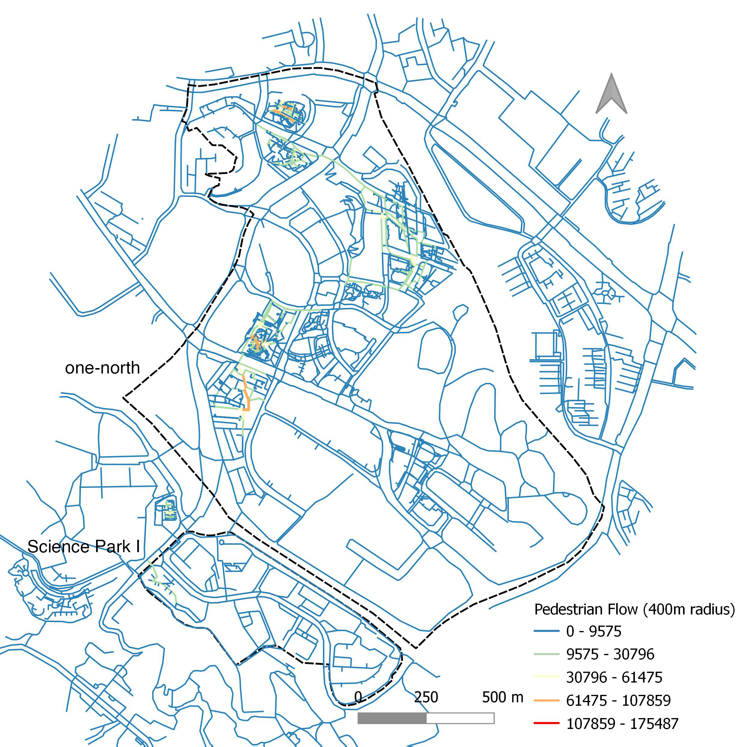
Figure 3. Spatial Network Analysis
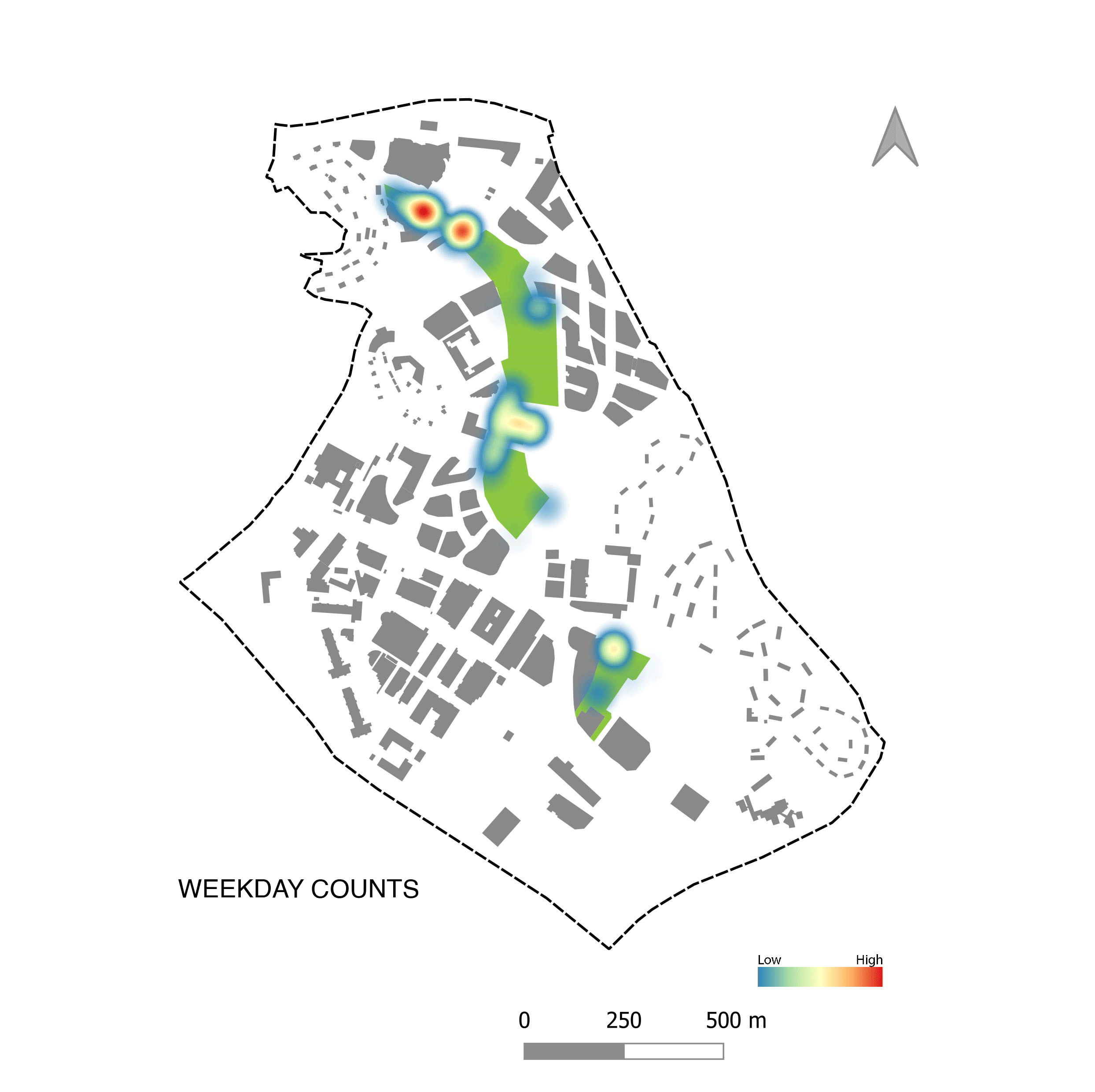
Figure 4. Pedestrian Mobility Mapping
In the Spatial Analysis, one-north district was observed to have high pedestrian navigability, and high density of closely linked public spaces and functions. The analysis shows that one-north outperformed a conventional business district in terms of pedestrian flows and levels of space occupancy. However, one-north Park only partially functioned as a connector within the district. The findings of this study contribute to the understanding of the association between vertical spatial configurations and dynamic pedestrian behaviour. The expected outcome of this Spatial Network Analysis-based approach is a multidisciplinary methodology to project pedestrian movement distribution patterns in similar vertical spaces in unbuilt districts.
In the Spatial-Visual analysis, one-north district overall showed a lower visual density of building and road features and slightly higher vegetation and terrain features. The analysis also highlighted the variation in urban visual features that corresponded to their different urban and environmental design approaches, with different visual zones displaying variations of ‘visual signatures’. These analytical mappings are useful as they can be geospatially located in relation to building, urban elements and movement networks and provide insight for future planned districts.

Fig.5 Radar Plot of features in subsites 6b Frequency Density graph, one-north and Science Park I
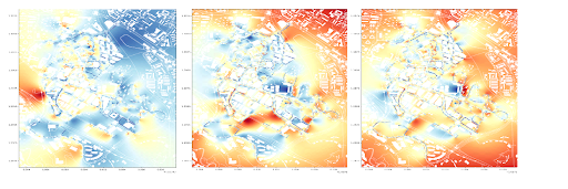
Fig.6 Interpolated heatmaps of (1) vegetation, (2) sky, and (3) road on the one-north and Science Park II.
4. Reference Links
Srikanth, A. D., & Schroepfer, T. (2023a). Network Science-based Analysis of Urban Green Spaces in Singapore. International Journal on Smart and Sustainable Cities. https://www.worldscientific.com/doi/10.1142/S2972426023400044
Srikanth, A. D., & Schroepfer, T. (2023b). A Spatial-temporal Network-Science Based Study of Walking in Urban Green Spaces: A Case Study of One-North Park. archiDOCT, 19(11 (1)). https://archidoct.scholasticahq.com/article/71450.pdf
Srikanth, A. D., Gopalakrishnan, S., Hablani, C., & Schroepfer, T. (2022, 18-20 July 2022). Exploring Spatial Patterns In Sustainable Integrated Districts: A Methodology For Early-Phase Urban Network Analysis. 2022 Annual Modeling and Simulation Conference (ANNSIM). https://scs.org/wp-content/uploads/2022/07/35_Paper_EXPLORING-SPATIAL-PATTERNS-IN-SUSTAINABLE-INTEGRATED-DISTRICTS-A-METHODOLOGY-FOR-EARLY-PHASE-URBAN-NETWORK-ANALYSIS.pdf
1 Introduction
As cities grow rapidly and urban populations expand, the balance between agriculture and natural ecosystems becomes more fragile. Switzerland’s voters have recognised the need to limit city growth and preserve land for agriculture to ensure sustainable development in urban areas. Therefore, densification has been established as a legally binding policy objective to create more housing. Cities are required to develop inwardly within their existing boundaries to achieve this objective.
As the largest city in Switzerland, its high quality of living and surrounding natural beauties are leading to a growth of 80,000-100,000 residents by 2040. The challenge is evident. Ranked as one of the most liveable cities in the last decade, Zurich sets high living quality as a permanent goal of city development. However, hardly any large areas can enable new development to accommodate this growth. In the latest city plan, Altstetten and Albisrieden were pointed out with great potential in creating new public spaces, increasing public utilities and facilities, and optimising energy consumption through urban fabric transformation towards high density due to their comparatively low density and well-connected public transportation and infrastructure. Given the above circumstance, the study selected Altstetten-Albisrieden as a real case to investigate strategies and approaches of urban densification and transformation in the context of Zurich.
This work package consists of two parts. The first part investigated building typologies and urban forms in Altstetten-Albisrieden and evaluated densification scenarios through quantitative methods. Some architectural design and urban planning strategies were proposed for future urban transformation. The second part studied urban transformation dynamics qualitatively through an architectural design studio, where densification was considered the main urban development logic. The design studio built “Room of Entanglement”, interpreting understandings of urban densification and transformation dynamics.
2 Building typology and urban form
2.1 Introduction
This session aimed to explore the potential of urban transformation from the perspective of building typologies and urban morphology in the Altstetten-Albisrieden district, enabling urban densification without sacrificing current living quality in the area.
The study systematically investigated the current building typologies and urban structure in Altstetten-Albisrieden and pointed out ideas for future place-making regarding connectivity and integration. By analysing the correlations between building density and green space provision, the study gave examples of potential building typologies among the existing developments in the district. Some densification scenarios were established accordingly, setting the foundation for discussing planning approaches and governance instruments. Some outcomes of the research work were tested in the Summer School Dense and Green Cities: Exploring New Models of Integrated Urban Development (052-0644-23L, FS2023) at ETH Zurich in July 2023.
2.2 Methods
a) Map building typologies
The study investigated building density and urban forms by mapping building typologies, green spaces, and infrastructure networks in Altstetten-Albisrieden based on the open-source data of Zurich, Open Street Map, onsite observation, and official parcel development documents. 2D GIS maps and 3D models of the case study were created to describe building features and calculate building density. Building attributes, such as building types, floor area ratio (FAR), Green space plot ratio (GsPR), and development year, were used to classify building typologies and generate district overviews of the current development situation. Important buildings and parcels with unique cultural or historical values were also marked as one parameter for future study on densification scenarios.
b) Investigate spatial connectivity and integration
Since most buildings in Altstetten-Albisrieden have one single function, the study used the 2D main street networks at the ground level and analysed spatial connectivity and integration via Depthmaps of Space Syntax. The analytical tools, angular segment choice and segment integration, were used to demonstrate the Through-movement and To-movement potentials in the city, respectively, at the pedestrian level (R=400-meter, 800-meter) and global level (R=2500-meter, 5000-meter, n).
c) Identify potential building typologies
Increasing building density usually reduces green space on the ground due to the mathematical relations between parcel area, building floor area ratio (FAR) and green plot ratio (GsPR). This inverse relationship between building density and green space provision can be varied by building typologies. The study aims to suggest potential building typologies that can increase building floor areas and provide plenty of open and green spaces to maintain the high quality of living in the district.
The study used FAR and GsPR as the main parameters to evaluate developments in the district. Building FARs and their corresponding GsPRs were displayed in a box plot. In line with the request to increase building density and green spaces, developments with FAR and GsPR higher than the mean values of all developments were filtered out. Examples of these potential building typologies were selected crossing Altstetten-Albisrieden. These examples were applied to create densification scenarios as the next step.
d) Densification scenarios and evaluation
Three densification scenarios were generated based on the results of the previous steps. Some premises, more specifically, the average sizes of residential spaces, workplaces, public parks, and sportive fields per person, were collected through building density calculation and literature reviews to translate population growth into the baseline of building densification requirements, Building and Zoning Plan of Zurich (BZO 2016). Building features, such as development year and structure types, were used to evaluate the feasibility of each scenario, which further indicated possible challenges and solutions in different scenarios.
2.3 Findings and outcomes
a) Building typologies and urban form
The significant development of Altstetten-Albisrieden started in the 1930s based on the communities Altstetten and Albisrieden. Today, the district Altstetten-Albisrieden is shaped by its topographic situation, its critical position in Zurich’s infrastructure networks and the “Garden Cities” concept being carried out well during the entire development period and is correspond by the building typologies and their allocation in the whole area, as shown in the section crossing the district (Figure 1) and land use of the district (Figure 2).

Figure 1: Section of Altstetten-Albisrieden district and building typology allocation.

Figure 2: Current land use in Altstetten-Albisrieden district.
Figure 3 and Figure 4 exhibit the development intensity of the district from the perspective of building intensity (built floor areas) in general and building FAR of each parcel, respectively. Land parcels developed for industrial and commercial purposes are built with very high density, and those for residential use have much lower building density. Some new residential developments, for instance, Freilager and Grimselhof, have comparatively high building density (FAR > 2.0).

Figure 3: Building intensity in Altstetten-Albisrieden district.
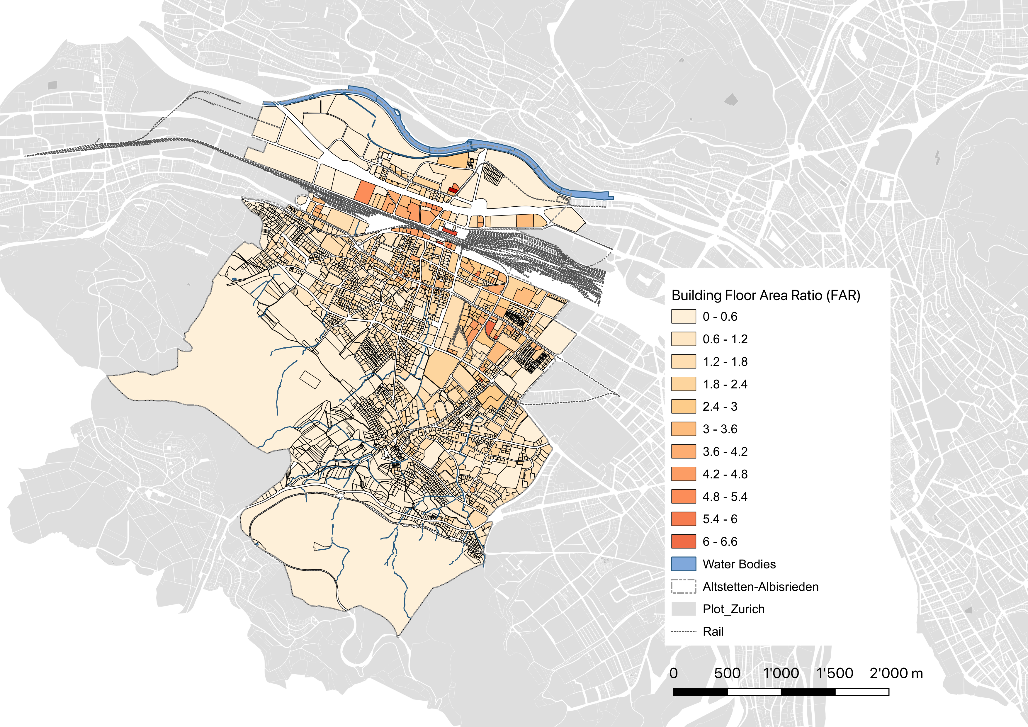
Figure 4: Building Floor Area Ratio (FAR) in Altstetten-Albisrieden district.
b) Spatial connectivity and integration
As shown in Figure 5, the integration analysis indicates a very strong To-movement (where people choose to go) potential in the city centre and the Schaffhauserplatz area, gradually extending to the North and the West globally. Altstetten-Albisrieden is situated at the edge of this high-potential area. Zooming into the pedestrian level, Altstetten-Albisrieden, a satellite community loosely connecting to the city, appears obvious. All streets in the district show relatively even roles without creating an evident reachable central area on foot, manifesting in both the central area and Schwamendingen quartier.
The choice analysis (Through-movement, how people choose to reach their destinate) demonstrated the significance of the main streets, A1 Expressway, Badenerestrasse, Baslerstrasse and Rautistrasse, leading the district towards the city centre and Europabrücke connecting Höngg and Albisrieden community centre. The analysis indicated more movement flows at the pedestrian level along Rautistrasse, Eugen-Huber-Strasse, Altstetterstrasser and Albisriederstrasse. These streets and their surrounding areas, specifically the Lindenplatz area, Albisrieden Centre area and Altstetten Community Centre, are suggested to have more shops, restaurants, and other facilities to realise place-making in the district.
Both integration and choice analyses display the significance of Europabrücke and its extension in the street network of the entire district globally and locally. This importance is justified by old maps and city plans since the 1900s, where the direct link between Höngg, Altstetten and Albisrieden was marked. Though heavy traffic and its disadvantages, like noise and air pollution, are obstacles to its transformation recently, strategies to activate the areas shall be considered for future development.

Figure 5: Integration analysis and choice analysis of Zurich by Depthmap, Space Syntax.
c) Potential building typologies
In line with the goal to densify the urban area without losing the quality of living, the study placed building density (FAR) and green space provision per parcel (GsPR) together to select potential building typologies among the existing developments in the district. The mean values, building density per parcel (FAR=1.01) and green space provision per parcel (GsPR=0.53), were used as the thresholds, as illustrated in Figure 6. Around 300 developments were filtered out, and six examples were selected along with the cross-section of the district (Figure 7). Except for the similarity that all six developments are high-rise buildings (around seven floors), these buildings covered the typologies in terms of
- Building function: multi-family residence, cooperation residence, and nursing housing
- Building structure: tower, slab, block, and courtyard
- Ownership: cooperative community, private residence, and social housing
These examples indicated that, with similar FAR, different building typologies can provide various GsPRs for parcels. Building typology selection and design play an essential role here.

Figure 6: Box plot diagram showing correlations between Building Plot Ratio (FAR) and Green Space Plot Ratio (GsPR) and demonstrating potential building typologies with FAR>1.01 and GsPR>0.53.

Figure 7: Examples of existing potential building typologies crossing the district.
d) Densification scenarios
To understand possible densification approaches and their impacts on green space provision, the study generated densification scenarios based on two premises resulted from the previous analysis.
- In Altstetten-Albisrieden, the average area for living is 45 m2 per person, and that for workplace is 40 m2 per position. In addition, every resident shares 0.65 m2 of public parks and gardens and 4.12 m2 of open green spaces for sports and activities. This information helped translate the district’s population increase into specific requirements for building and green spaces that the district shall increase over 800,000 m2 building floor areas and approximately 66 hectares of green spaces.
- The average life span of a building is 46 years, according to the current development pace in the district. Hence, buildings constructed or renovated before 1980 have great potential for redevelopment in the coming decades.
Scenario 1: Full capacity of BZO 2016
In the first scenario, the district’s allowable capacity was assessed via the latest Building and Zoning Plan of Canton Zurich (BZO 2016). Regardless of the age and lifespan of the buildings, the calculations demonstrated that the entire site could support the projected population growth. However, the study also pointed out the difficulties of creating green spaces near buildings and maintaining public green space sharing at the current level. Furthermore, some small land parcels with private ownership would need to be expanded to accommodate reasonable building volumes while adhering to all the restrictions specified in the zoning plan. Combining adjacent parcels to increase usable building footprints could be a practical solution, particularly in the three-floor (W3) and four-floor (W4) residential zones.
In Scenario 1, the city’s response to the growing population in the urban area is evident. Most of the land parcels that can be built on were upgraded from BZO 99 to BZO 2016 to allow for more building floors for future population growth. However, the green spaces and fields that were previously reserved remain the same. The importance of green spaces, environment, and ecosystem was not prioritised until the emergence of Zurich Richtplan 2022, which emphasised the need for green spaces and corridors to enhance the city’s ecosystem services and microclimate. Therefore, addressing the crucial issues of where to realise densification and how dense to make it are essential strategies and approaches.
Scenario 2: Partially intensified densification
In the second scenario, the lifespan of the buildings was taken into account. Based on the two premises mentioned earlier, it was calculated that over half of the buildable parcels were developed before 1980 and could be redeveloped with higher building density (as shown in Figure 8). To increase the building floor area, the redevelopment should have an average building density of 1.40 (FAR=1.40). However, different densification measures can lead to various consequences and challenges. For example, if adding floors above existing buildings is used as the main instrument, all buildings must add an average of two extra stories. The challenge here is the strength of the existing building structures, particularly those built in the 1940s and 1950s. On the other hand, if building replacement is used to densify these areas, the average height of all redeveloped buildings will be four floors. However, either way, the loss of shared public parks and gardens, green spaces for sports activities, and greenery near buildings is inevitable (about 18.7%). This indicates a decline in the quality of living in the district.

Figure 8: Potential redevelopment land parcels developed before 1980.

Figure 9: A simple calculation of densification based on the preconditions and the potential building typologies.
Scenario 3: Greenery-oriented densification
The third scenario prioritized the requests of increasing green spaces, including parks, gardens, sports fields, and greenery near buildings. The study used building typologies from Figure 9 to determine that any redeveloped parcels with a Floor Area Ratio (FAR) greater than 1.54 could potentially provide open green spaces at the ground level. The higher the FAR, the more ground space that could potentially be freed up for public use. The study also found that a FAR of at least 2.50 and a green surface plot ratio of 0.55 or greater could overcome the challenge of increasing building floor area while also providing green spaces, in line with Zurich’s latest building and zoning plan.
This scenario analysis proposes that:
- The addition of public green spaces, like parks, gardens, and sports fields, can be achieved by slightly increasing building density in the area. However, the challenge lies in maintaining these green spaces near buildings, as they impact the microclimate of the whole area and the availability of community green spaces. To maintain the current resident-share ratio of these green spaces, new developments must be built in a compact manner.
- As parcels of land become more densely developed, there is a decrease in green spaces near buildings (as shown in Figure 8). The main concern is increasing the green surface plot ratio (GsPR) for each redevelopment. Therefore, building typology designs with more green surfaces are crucial, and the inclusion of greenery elements like rooftop gardens and green facades should be encouraged.
- While the latest building and zoning plan, BZO 2016, specifies the minimum open space for each parcel, there should be clear limitations on the green surface plot ratio to promote the growth of green surfaces around buildings.
3 Urban transformation
3.1 Introduction
Urban complexity, representing the interdependent relations between urban elements and subsystems, displays individual diversity and variety. Understanding urban complexity also requires respect for subjectivity and individual interpretation beyond general rules and principles. In other words, research truly reflecting urbanisation and urban development must include the discussion of deducing simplified standards to context-specified situations and cases.
Observing the complexity of urban and urban development advances dialogues and discussion, crossing multiple transformation dynamics for cooperation and leading to a deeper form of engagement based on the premises, such as more than one understanding of urban transformation, densification as a dominant driver rooted in social-political dynamics, the necessity of reconsidering other potential drivers of urban transformation, and the needs to introduce new readings of urban transformative moments.
Therefore, this session shifted the research focus from the objects of urban densification to a more relational approach, intending to reveal and activate the interdependence between urban elements and subsystems. Specific interests and attention were drawn towards the urban frameworks that capture and guide urban transformation dynamics in the district. In this sense, the latest Richtplan of Zurich became an object of this study. Based on the case study in Altstetten-Albisrieden, Zurich, this session aimed to demonstrate both systemic and experienced urban transformation dynamics and explore the role of the Zurich Master Plan (Richtplan) in urban transformation dynamics. It argued a method introducing complementary approaches to create a fruitful environment for planning administrations and practitioners that enables integrated district development.
3.2 Methods
The study invited individuals to approach urban design and urban transformation differently to fulfil the aims of this session and realise the engagement from various perspectives. Individuals first investigated given urban elements beyond static qualities, reconsidering their roles in their functioning surroundings, generated interrelation systems and potentials, and then discussed interactions, engaging and testing. This reiterative process enabled the study to identify crucial notions that helped to display specific qualities and interpret local transformation dynamics. Furthermore, these notions allowed for establishing dialogues between them and existing practices to re-evaluate their positions and the likelihood of adapting to varying situations.
To examine the Zurich Richtplan’s role in densification, the study selected seven ongoing development projects in Altstetten and Albisrieden to investigate the densification logic of the district. These projects covered building types, such as schools, housing, retirement residences, and surrounding areas, such as public open spaces, green spaces, and allotment gardens. A close look at these projects explored the influence of the densification program on public space provision in the districts of Altstetten and Albisrieden.
This study established an immersive space named “Room of Entanglement” as a part of the design studio to inspire individuals rethinking urban elements in urban transformation. By changing the scenography of the room, the varied atmosphere stimulated individuals to break through the restraints of current ways of thinking on buildings, targeting interrelations and connections, longer life spans, and actual lives of dwellers in the district. In addition, the Room of Entanglement, with graphics and models representing real examples and elements, activated discussions and dialogues between involved stakeholders. The encounters of different readings and opinions towards densification and urban transformation crystallised the crucial moments in the dynamic transformation process without hierarchy. They permitted open-ended interactions that enriched personal views of the city and its transformation.
3.3 Findings and outcomes
a) Notions representing the quality of urban transformation dynamics.
The study identified six notions to represent the quality of urban transformation experienced in the Altstetten-Albisrieden.
- Affordances shed light on the design features of objects or spaces that prompt or promotes a specific use or interactions, such as a sidewalk of a street, introduced by J. J. Gibson.
- Adaptive infrastructures institute the function as a medium to enrich its environment, foster social and spatial connections and support new forms of collectivity and coexistence through redesign and reinterpretation.
- Traces consist of inspiring elements that trigger personal emotions without constraints and indicate personal connections with the site that both intangible and material aspects can provoke.
- Cultural habits are non-physical materials of a city, defined by norms and societal agreements relevant to customs and everyday practices, requiring an attentive reflection to understand the intervention of such agreements on socio-spatial organisation.
- Performative structures suggest a transformative framework integrating existing configuration, networks and flows through a specific observation lens and play an essential role in generating a strategic roadmap for a city to balance long-term and short-term arrangements from different perspectives.
- Unlearning moments allow questions towards existing professional positions by introducing new rituals and fostering future collectives and provoke a rethinking of engaging with reality and embracing complexity or new cultural habits.
b) Cartographic explorations
The study explored different cartographic possibilities to capture a more entangled way of understanding the urban transformation dynamics of Altstetten and Albisrieden and resulted in three maps described below. Each of these three maps attempts to construct a less systematic but more instinctive aesthetic of the district. Instead of representing actual data through observation, these maps mix varied scales and 2D or 3D elements to introduce differences of focus, strengthen narratives, display frictions, give the context a multitude of textures and ultimately indicate alternative scenarios and interpretation of densification and transformation dynamics in the district.
- Landscape of care (Figure 1)
The map “Landscape of care” unravels the interrelation between different landscape typologies crossing the district and their possible carrying roles in urban revitalisation.

Figure 1: Landscape care
- Suburban encounters (Figure 2)
The map “Suburban encounters” highlights the co-existing of urban functions and their close connections means influenced by land parcel configuration and urban circumstance.
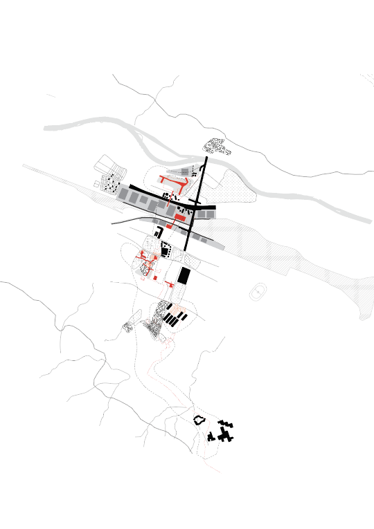
Figure 2: Suburban encounters
- Beyond centrality (Figure 3)
The map “beyond centrality” demonstrates the civic qualities of existing open public structures and the organisation of surrounding buildings and facilities stitching together into fine-grained walkable neighbourhoods across the district, indicating an alternative to the logic of developing a more centralised area.

Figure 3: Beyond centrality
c) Room of Entanglement as a part of the Design Studio on Altstetten
A Room of Entanglement was established to invite dialogues and engagements between stakeholders and students in various performance formats. The Room of Entanglement consists of Five rooms, responsible for collecting elements that compose or reflect the site, structuring an alternative strategic map to represent densification potential, dividing the map for parallel sketch, and converting diagrams into a carpet.
The Room of Entanglement created an everchanging environment to generate transformation scenarios and key projects. Four design tracks appeared with their significancy during the course. They are:
- Scenography: a collective output of the design studio and a setting where individuals or the team communicated and discussed concepts or interventions. The scenography set up a temporary space that evoked atmosphere for different performance and conversations.
- Ritual: a series of performances blurring authors and audiences to enhance the moments of trust and sharing.
- Elements: a series of subjects conveying proposed interventions, assumptions, emotions, and worldviews. Elements were collected to bridge a subjective reading of the site with other contexts.
- Framework: a further mapping process to re-interpret Zurich Richtplan and finally create a collective reconstruction or deconstruction of a common interpretation of urban densification and transformation dynamics of Altstetten.
Via the performance and dialogues the Room of Entanglement, the study looked at ways of transforming urban areas by involving everyone in the process. It found that densification is only one approach and multiple strategies should be used to tackle urban complexity.
d) Adaptive infrastructures
As one of the notions, adaptive infrastructure displayed its significance due to its remarkable roles in urban transformation metabolism and its encompassment of long-term public investments. These infrastructures strongly interweave within the urban fabric and connect with residents and their daily needs, yet they are rarely considered part of development logic. Design plays a vital role in strengthening the adaptive character of urban infrastructure. The study constructed an alternative framework for the densification in the district. It developed a design language to assist in understanding the contribution of public infrastructures to the development of the district more precisely. Within this sense, the study drew a new map to re-engage stakeholders and involved actors in the
- Intimate infrastructure: the infrastructure in the district contributing to a particular human comfort and convenience in everyday life. Instead of a monolytic pattern, this mapping layer investigated the diversity of daily life in Altstetten-Albisrieden.
- Urban patterns: the urban contexts in which those infrastructures are related. This mapping layer described the urban textures as a collection of streets, buildings, open spaces, and other facilities from a human perspective, and investigated their relations with the infrastructures.
- Rooted infrastructure: elements and networks often neglected in the district, such as underground water, ecosystem, and pedestrian flows.
- Intervention zones: overlapping the previous three mapping layers, some new possible intervention zones emerged because of their strategic roles at the specific intermediate scale. This mapping layer demonstrated the contribution of single projects to a larger urban fabric.